
Cuatro Cienegas


- Details
- Category: Blog
- Published: Thursday, 07 April 2011 22:15
- Written by Administrator
- Hits: 32757
CUATRO CIENEGAS: LAKES IN THE DESERT
Explorations in the oasis of Sierra San Marcos y Pinos, in Coahuila, in search of caves and origins of waters which formed them.
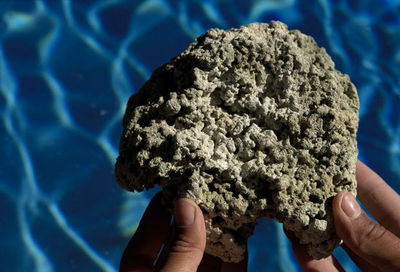
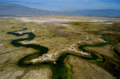
The karst area of Cuatro Ciénegas is an immense valley with a semi-desert climate located in the state of Coahuila, in northern Mexico. It is surrounded by calcareous mountains, up to 3,000 m high. The basin is characterised by wonderful spring lakes and by a totally unknown groundwater intake, a crucial resource at risk of depletion.
 Between 2000 and 2002 La Venta Association carried out in this area the “Cuatro Ciénegas Project”, a series of hydrological and speleological researches which have been recorded in a large format book, including an interactive CD-ROM.
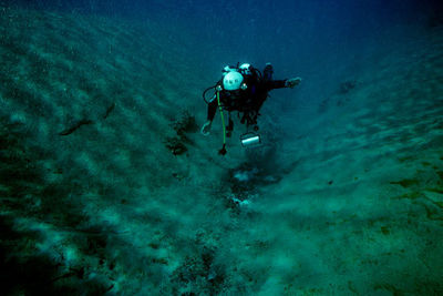
Explorations in this region had the purpose of shedding light on the origins of around 200 crystalline pools, of various sizes, appearing in the region of Cuatro Ciénegas as a mirage in the desert. These bodies of water have been the subject of specialised studies on the fauna, from fish to bacteria, because they re-establish similar conditions to those of the origin of life on our planet. The great interest around these desert pools and their uniqueness has allowed the protection of them by creating a national park in 1994. However, nobody has still found an answer to the following questions: where does this water come from? Why is it hot in some points and cold in others? Why is there so much water despite the lack of precipitation?
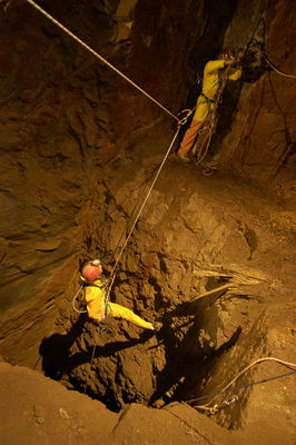
After carrying out two investigations in 1998 and 1999, La Venta organised three important expeditions. The search for the origin of the mysterious waters started from these pools, with underwater explorations, analyses, monitoring and positioning through complex satellite systems. Later, we focused our attention on the mountain ranges surrounding the valley, up to 3,000 m high and on the caves opening in them. Finally, some ancient mines, hundreds of years old, were explored, not without risks, trying to reach the stratum waters in the heart of the mountains.
 Here are some figures of the project that give an idea of the work performed: more than 70 researchers involved, 65 new caves explored, 8 km of underground topography, almost 200 geo-topographic observation points, tens of underwater immersions, thousands of metres of rope used within pools in mines and caves, thousands of kilometres walked, amongst all participants, on giant mountains without paths. Not to mention the numerous canyons descended for the first time by man.
The explorations gathering and comparing data concerning pools and caves allowed us to develop concrete scientific hypotheses on the origin of waters of Cuatro Ciénegas and the development of karst in the area. In addition, thanks to the support of the local government, these explorations will represent the basis of each future strategy for the conservation and tourist development of the valley and the surrounding mountains. Researchers of our team, who faced various difficulties in working on the Cuatro Ciénegas Project, hope that understanding what hides under the desert will help us to better protect, and perhaps only just in time, one of the Earth’s most beautiful places.
Partners: Expeditions were organised by the La Venta Association together with the following bodies: Gobierno del Estado de Coahuila, Istituto Nacional de Ecologia de Mexico (SEMARNAP), Area de Protecciòn de Flora y Fauna Cuatro Ciénegas, Secretaria de Fomento Economico de Coahuila.
Future plans: results of explorations are fairly clear. There are still some places that need to be further explored around the Sierra San Marcos y Pinos; however they don’t require an ongoing targeted project. Opportunities for important explorations mostly depend on the casual discovery of accessible halls to hydrothermal karst systems, not on land morphology.
1999 Explorations
 During two investigations carried out in November 1998 and May 1999 two large caves located downhill, both near the dell and on the high surrounding mountains have been partially explored.
During these investigations we explored around 5km of underground tunnels, although most of these have not been fully explored. In some canyons we saw tens of caves with halls opening on vertical walls, thus we could only reach them through climbing techniques: free and aid climbing, fixed rope ascents.
In order to explore these caves and to discover new ones it will be necessary to equip advanced base camps in canyons and mountains, overcoming difficulties due to water transfer (there isn’t any known spring). As regards extremely deep and complex caves it will be necessary to equip base camps inside the caves.
During cave explorations we will carry out instrumental mapping, observations and geological sampling, surveys on physical data such as temperature, air flows, relative humidity, etc.
As regards the spring lakes, research will be based on the underwater topography of the most significant pools and on the exploration of conduits that will be discovered. The goal is to produce the minimum impact on submerged ecosystems. Moreover we will try to describe through topographic mapping the morphology of inflow and outflow conduits in relation to the lithology of the explored sites.
Specific hydro-geological studies will be carried out on water bodies: precise height measurements of each lake on the mean sea level and comparison of relative heights; measurements and comparison of temperatures; various types of chemical and physical analyses; measurements and monitoring of flow rates and levels, calculations of the speed of flow of intake conduits and drainage galleries.
In the end a subaqueous photographic documentation will be realised, as it does not yet exist.
2001 Explorations
The 2001 “Proyecto Cuatro Ciénegas” was aimed at understanding the hydrogeology of the dell, the actual extension of the drainage basin, its geological history, and the reasons for its pollution as well as the ongoing salinization.
The karst area of Cuatro Ciénegas is an immense valley with a semi-desert climate located in the state of Coahuila, in northern Mexico. It is a crucial resource at risk of depletion.
The basin is surrounded by calcareous mountains, up to 3,000 m high and is characterised by wonderful spring lakes and by a totally unknown groundwater intake. Research has involved Italian and Mexican researchers for several years and resulted in a greater knowledge of this area. Explorations have also allowed us to identify concrete measures to protect and improve this area, both as a drinking water reservoir and as a sustainable tourist destination.
Archaeology
In the pre-Hispanic period, the region of today’s state of Coahuila was part of the enormous cultural region known as Arid America, covering the area extending from Northern Mexico to the South-West United States. The region was divided into the following sub-areas: Central and South California, Great Basin, North-West Arizona, Apacheria, Lower California, Sonora and Sinaloa Coast, Southern Texas and Northern Mexico. This last sub-area belonged to the present state of Coahuila.
 Aztecs used to define Arid America as “The Land of Chichimec”, namely “the land of dogs people”, who were essentially nomads. Arid America had always been the most conservative cultural area of the whole American continent. Up until the period when local populations first came into contact with the Europeans, in these areas “archaic” lifestyles were endured that in other areas had been abandoned thousands of years before. For instance, in Meso America the so-called “Archaic period” lasted approximately until 1800 B.C, meaning that in the whole Arid America (except from a sort of island in the South West of the United States called Oasis America) farming was never performed, ceramics were never used, monumental buildings were never built and states were never created.
Arid American populations were organized in small groups of nomad hunters and pickers and their cyclical movements depended mainly on sources of available water. They survived in the desert environment basing their subsistence on desert plants such as pithayas, yuca roots, agaves, mezcal, palm-trees, roots and tubers, indian figs, on animals like foxes, hares, rabbits, rats, snakes, birds, insects and on natural products like honey.
All groups were commanded by a head-man. Normally they occupied leading positions because of their personal status and they headed fights against rival groups. People used to live naked or wearing vegetal fibre or leather loincloths. They used to walk using sandals made of interweaved fibres. They had long hair, loose or braided, tied up with a coloured band on the forehead. They were very keen on creating tools, for instance they used to weave baskets, build wooden darts with flint tips which were thrown through propellers, stone grinders and pestles to grind the seeds they picked and working tools made of bone or horn.
Very little is known about their religious and spiritual practices. We know that they used peyote in order to have visions during ceremonies and while dancing through the music of drums, bells, pumpkins and snake rattles. They certainly possessed a well-articulated oral tradition. In fact,
we know that in some cases they used to wrap dead bodies in wicker mats or tie them up in funerary bundles. Considering the situation, it is not surprising if Aztec informers of Bernardino de Sahagún described “the Land of Chichimec” as follows:
“It is a land of misery, of sorrow, of suffering, exhaustion, of poverty and anguish. It is a land of dry rocks, of failure, a place of lament, of death, thirst, of starvation. It is a place of much hunger and death.”
Ethnic history of Cuatro Ciénegas
The historical and ethnographic documentation of the colonial era, regarding the period between 1650 and 1750, proves that the region of Cuatro Ciénegas was populated in this century by various indigenous groups, known as the Coahuileños or Coahuilas, who were widespread in the whole region, north and north-east of the district of Parras-Laguna.
These groups, belonging to the hokano-coahuilteca language group, lived in the area extending from Mapimì to Monclova and Cuatro Ciénegas. According to historical sources, in the region of Cuatro Ciénegas, there lived among others, groups known by the following names: Cabezas, Salineros, Cíbolas, Baborizagames, Baborimamas, Corcobados, Ygoquibas, Yguitoros and Contotores.
It is difficult to find out if names mentioned in various documents referred to ethnic groups, “gangs”, or even to simple family groups. These gangs were normally united by unstable and ephemeral alliances and wandered in the region performing raids against rival groups. In many cases gangs of Coahuileños were allied with (or, alternatively fought against) the Tobosos, a large group of vague affiliation populating the northern regions of Coahuila. It is likely that the habit of forming large alliances, often under the guidance of one single leader, was an innovation of the colonial era, due to the presence of a new common enemy: the Spanish invaders.
The fight against Spanish colonisers caused a rapid decline in native groups of the area and by the mid XVIII century they had almost completely vanished.
New indigenous groups benefited from this situation and moved into the lands of today’s state of Coahuila. Populations that moved in this region were the uto- Aztec, the Comanche and above all, from 1740-50, the Apache, an indigenous group belonging to the Athabaskan language group, whose origins were to be found in what is today Canada. This group occupied almost the whole region. However, they too very soon became a target of the new colonial world. In fact, nowadays native inhabitants of the region of Coahuila have almost entirely disappeared.
Archaeological research in Cuatro Ciénegas
Among various regions of Arid America, the area of today’s state of Coahuila has been carefully studied on an archaeological level and is the source of most of the available data on the Arid American prehistory.
The Bolsón of Cuatro Ciénegas and the nearby canyons were explored between 1937 and 1947 by Walter W. Taylor during his Coahuila Project, which was partially funded by the United States National Museum of the Washington’s Smithsonian Institute. Taylor explored several caves of the region (ignoring the rare and poorly preserved open air sites), though results of researches were only partially published.
The archaeological heritage of the region of Cuatro Ciénegas is essentially characterised by cave sites and forms of cave art. In cavities all over the region traces of temporary human activities were discovered, fireplaces, several tools used for daily activities. Also various funerary sites were discovered, where dead bodies were wrapped in mats and covered with masses of stones. Cave art is particularly abundant and generally characterised by geometrical images of various colours, such as red, yellow and ochre. In some cases vertical and long anthropomorphic images can be observed, perhaps depictions of “spirits” of men during ecstatic experiences.
Research performed by the La Venta Association during the Cuatro Ciénegas Project do not have (at least for now) specific archaeological purposes, however throughout explorations of the area we have surprisingly found several archaeological elements, such as arrow heads, cave paintings and numerous funerary sites one of which was characterised by the presence of mats.
The main discovery has certainly been a refuge with a 30 m rock wall, covered with wonderful polychromic paintings. All archaeological findings have been documented with numerous photos and, clearly left in situ without altering their original conditions.
The archaeological sequence of Cuatro Ciénegas
The most ancient archaeological findings discovered in the state of Coahuila date back to the end of Pleistocene and consist of spearheads found in the Cueva Espantosa and in La Chuparrosa.
However, at the beginning of the Holocene some of the most important cultural traditions of the area developed, related to the so-called “Desert Tradition”, represented mainly by the Bolsón of Cuatro Ciénegas.
|
INSIGHTS: |