Patagonia


- Details
- Created: Thursday, 07 April 2011 17:53
- Published: Thursday, 07 April 2011 17:53
- Written by Administrator
- Hits: 34590

PATAGONIA: GLACIER HYPER-KARST AND EXTINCT POPULATIONS
Explorations between crystallized vortices of the Hielo Continental and lost populations.
 South America is a strip of land that juts out into the vast Southern Ocean, and cuts it across. Those areas, at this point sub-antarctic, have been ignored for centuries because of their inclement weather. The sailing ships bypassed them, so the people who lived there survived until the beginning of the XX century. Descendants of the men and women who went farther, from their original birthplace in Africa.
The interest in these areas started at the end of the XIX century, when the advent of the steamships made it possible to sail against the wind in the Strait of Magellan. Several cities were founded, but in short time the settlers came into conflict with the indigenous people, and eventually exterminated them, a genocide so remote and total.
The ablation zones of Patagonian glaciers are at 0 °C, therefore their karst topography is the same as alpine or central Asian glaciers.
In fact, the morphological nature of Patagonian glaciers is unique… perhaps only glaciers in southern Greenland have similar features.
Mountain or valley glaciers shave small ablation basins similar to the ice lobes flowing down the glacier.
The lobes are then relatively little fed and in weak equilibrium with the feeding zone. Ice is relatively recent and has not yet freed itself from air bubbles; this is why it has a grey and dull colour. At a few metres beneath the surface we are already immersed in the dark.
 Normally seasonal cycles allow the inside of rocks (also of ice, caves and cellars) to reach a temperature that is very close to the yearly average temperature of the place they are exposed to. A few metres below the surface, the rock reaches 15 °C at the sea level on the coasts of Liguria, 8.5 °C at 1000 m asl., 2 °C at 2000 m, and falls below 0 °C over 2500 m... Ice too is forced to such temperatures and is stable only above the mean yearly isotherm 0 °C. Nowadays on the Alps the isotherm zero and glacial fronts are found at 2500 m asl and they are likely to rise because of global warming.
In Patagonia, the accumulation basin is the Hielo Continental Sur, a glacial surface extending for over 20,000 km2, thus much larger than each tongue draining it, overall of 2-3,000 km: Upsala, Viedma, Perito Moreno, Tyndall, Grey... Ice remains in the accumulation basin for various centuries and absorbs all trapped air bubbles, becoming transparent and bluish. Lobes are overfed with ice thus they are very quick and can penetrate up to very low depths before melting. In particular, glaciers like the Perito Moreno or the Upsala flow at altitudes where the yearly average temperature is around 5 °C, as if on the Alps there were glaciers flowing at 1500 m asl. Of course at such altitudes the ablation is very intense, we measured over 20 cm a day, and therefore caves have a very rapid and unique development.
Geographical area: extreme south end of South America, between Hielo Continental Norte and Ushuaia.
Future plans: studying the development of karst topography in Patagonian glaciers can help us understand their behaviour is this stage of climate changes. It is necessary to keep on exploring and documenting the evolution of glacial caves, focusing on locating rock caves with an archaeological potential.
Patagonia: Crystallized vortices
Patagonian glaciers
La Venta achieved its most extraordinary results right in the glaciers of Patagonia, both from the point view of explorations and of scientific research.
In 1991 a short expedition on the Marconi Glacier (Argentinean Patagonia) allowed us to study the phenomenon of crystallized vortices in a relatively restricted area. In 1994 a second expedition, on the glacier Perito Moreno, succeeded in finding a series of very interesting glacial moulins and in gathering crucial information (regarding logistic and transports) for a new and more complex expedition.
 In March ‘95 the “Hielo Patagonico expedition” began, involving sixteen researchers and more than two tons of equipment. The subject of this study was the Perito Moreno Glacier, one of the “small” lateral ice tongues (60km2) coming down from the Hielo Continental (over 400 km long), the world’s largest ice mass outside of the polar regions. During the expedition 11 cavities were explored and descended, covering a total of 1200 km on the glacier. The Perito Meccanico cave was partially explored and studied though topographic mapping. With a development of 1040 m it is the world’s longest endoglacial tunnel. It was also necessary to assess the duration of explorations because the water regime could suddenly change (from 170 to 3500 litres per second in a few hours). Fluorescein tests were performed in order to trace the flow of the groundwater. We also explored the cave of Coltrane, which is probably the most interesting and fascinating cavity both for its size and its incredible brightness, even at great depths. The ice is particularly pure and compact and allows the light to break through, even if just in its blue component, up to 60 m depth, creating environments that even best quality pictures can hardly reveal. In addition, the first speleological dives in the world were performed, both in flooded crevasses and in horizontal tunnels. Immersions require complex equipment and a long experience; let’s just consider that the temperature of this water is 0 °C and that it is the first time that such methods and exploration techniques have been applied in this field.
During the expedition were realised live broadcasts for the TV program “Ultimo Minuto” (RAI 3) and for the documentary “La Compagnia dei Viaggiatori” (Canale 5). Moreover, when we came back to Italy we were interviewed by RAI 1 and RAI 2. Articles were also published in the review “Alp”, “Airone”, “Acqua”, and in February 96 in the National Geographic Magazine.
In February ‘97 a new exploration on the Viedma Glacier (Argentinean Patagonia) and on the Cordillera Darwin (Tierra del Fuego, Chile) paved the way for future projects. The expedition aimed to analyze glacial karst topography in areas representing absolute challenges from the point of view of organization and logistics, mainly because of the distance and the surface to explore
- 1991: Marconi Glacier, 8 people - 5 days
- 1994: Perito Moreno Glacier, 3 people - 15 days
- 1995: Perito Moreno Glacier, 22 people - 18 days
- 1997: Viedma Glacier, 6 people - 10 days
- 2004: Upsala Glacier, 14 people - 18 days
- 2004: Grey Glacier, 11 people - 16 days
The Perito Moreno Glacier – Argentina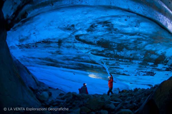 This was the subject of an investigation in 1994 and an expedition in 1995, during which a documentary and various short films were produced. This glacier is well-known for its large basin, drained by a relatively small and short glacial tongue. Glacial shafts are numerous and often huge. The main drainage is at the centre of the tongue (Rio Malbec) which plunges into a huge shaft. However, it is impossible to explore it because the waterfall has a flow of numerous cubic metres per second. The shaft re-forms several times throughout one season, leaving fossil conduits at the bottom of the absorption. We explored one of them, the Coltrane, sixty metres deep, followed by huge tunnels for two hundred metres. The stream is absorbed downstream in the runoff area before the glacier front. Perhaps it cannot penetrate before because the ice at the centre of the tongue is extremely compact as it moves uniformly. Other glacial moulins are to be found all along the ice tongue, but on its sides, where ice flows in various ways, creating more permeability. However, the most interesting aspect is the development of deep, horizontal cavities. Another stream, flowing parallel to the Rio Malbec, on the right hydrographical side, disappears without gaining much depth and carries on beneath the surface at 5-20 m. We explored and detected 1150 m of this cave, which is the longest glacial cave in the word. The fluorescein test showed that, before re-emerging and joining the Malbec, the stream covered twice the distance we observed. Also on the left side of Rio Malbec we found strong evidence of deep runoffs, but we did not explore them. Projects: a new expedition is required to compare the situation of this site ten years later. Moreover, it is necessary to discover if there are natural springs (discharges) in the floating front. Difficulties: activities do not present major problems, easy approach, easy access to central zones, and base camp area close to the working areas.
The Viedma Glacier – Argentina
This was the subject of an investigation in 1994 and an expedition in 1995, during which a documentary and various short films were produced. This glacier is well-known for its large basin, drained by a relatively small and short glacial tongue. Glacial shafts are numerous and often huge. The main drainage is at the centre of the tongue (Rio Malbec) which plunges into a huge shaft. However, it is impossible to explore it because the waterfall has a flow of numerous cubic metres per second. The shaft re-forms several times throughout one season, leaving fossil conduits at the bottom of the absorption. We explored one of them, the Coltrane, sixty metres deep, followed by huge tunnels for two hundred metres. The stream is absorbed downstream in the runoff area before the glacier front. Perhaps it cannot penetrate before because the ice at the centre of the tongue is extremely compact as it moves uniformly. Other glacial moulins are to be found all along the ice tongue, but on its sides, where ice flows in various ways, creating more permeability. However, the most interesting aspect is the development of deep, horizontal cavities. Another stream, flowing parallel to the Rio Malbec, on the right hydrographical side, disappears without gaining much depth and carries on beneath the surface at 5-20 m. We explored and detected 1150 m of this cave, which is the longest glacial cave in the word. The fluorescein test showed that, before re-emerging and joining the Malbec, the stream covered twice the distance we observed. Also on the left side of Rio Malbec we found strong evidence of deep runoffs, but we did not explore them. Projects: a new expedition is required to compare the situation of this site ten years later. Moreover, it is necessary to discover if there are natural springs (discharges) in the floating front. Difficulties: activities do not present major problems, easy approach, easy access to central zones, and base camp area close to the working areas.
The Viedma Glacier – Argentina
This glacier has been the subject of a complex investigation in 1997.On that occasion we were only able to explore the section surrounding the base, located at the Hielo Continental hut. Aerial surveys were carried out in 1995 and 2004. The Viedma is one of the most impressive glaciers, perhaps the most spectacular one. There are various glacial moulins, but surface conditions are diverse and create several landscapes.
Its irregular shape, almost triangular, with a huge drainage basin and nunatak, splits in different sectors, often divided by seracs that are very difficult to cross and destroy its hydrography.
In general, water absorption takes place rapidly in rather small shafts, although at the centre of the ice tongue there is a large stream which apparently disappears in the pre-stretching area at the end of the lobe. Other particularly interesting areas seem to be those near the central nunatak. We found signs of the existence of deep tunnels. Projects: Currently it seems to be the most interesting glacier to explore. One or two expeditions will be necessary. Explorers will need to be divided into several teams in order to study different sectors because the glacier is too vast and not at all easy to cross. Difficulties: there are major problems approaching the glacier, a helicopter is required to transport equipment and to locate teams. Some troubles in moving on the ice. Base area is very far from the working area.
The Upsala Glacier - Argentina This was the subject of aerial surveys in 1995 and an expedition in 2004. The recent phase of catastrophic retreat has had an enormous impact on the glacier. We assessed that, in the last fifteen years, the ice level has fallen by around one hundred metres, losing tens of cubic metres of water. According to scientific reports, the negative mass balance has worsened because two ice caps located at the glacier’s front, on which the glacier leaned on, disappeared by the mid 90’s, during its slow gradual retreat. These ice caps were crucial as they prevented the glacier from sliding down into the lake.
As a result, the ice tongue has slipped downstream undergoing extensive flow and opening crevasses perpendicular to the flow vector at 12 km from the glacier front! Consequently, drainage channels have totally disappeared, both inside and outside the glacier. Once we had solved technical problems preventing us from accessing central parts of the glacier, we found several signs of karst topography, though rather fragmented due to the presence of crevasses. The only karst areas were found at the foot of the crevasse field and some small areas on the front of the left tongue. The first one was found upstream of the Laguna Azul, the only zone where the ice could be crossed. There are various medium-size streams plunging into small shafts. There was no trace of fossil cavities due to the slow ice flow therefore it was impossible to perform significant explorations. Caves that formed within the left ice tongue are far more interesting, though they will probably disappear very soon at the current ice-melting rate. These karst formations are mainly found on the surface, with large but short tunnels and have most probably formed at the bottom of ancient lakes. These structures turned out to be very interesting as they allowed us to study micro drainage structures within the ice mass.
Projects: at present, the glacier’s karst topography has not yet been studied, except for some targeted analyses.
Difficulties: serious problems to approach the glacier due to its large size, great distance from working areas, big problems to move on the ice surface.
The Grey Glacier – Chile
This was explored during an expedition in 2004. Its ice is very similar to that of the Upsala Glacier and, in this case too, explorations were mainly concentrated on the left orographic tongue. It is also going through a phase of retreat, though less catastrophic if compared with the Upsala. The left lobes have a fan-shaped drainage pattern, with small streams flowing in huge but flattened valleys. Streams plunge into large but not deep shafts, which are normally filled with water. After all, it is normal to find flooded shafts on the surface. We explored 17 caves, up to 70 m deep, but with limited development. On this glacier the phenomenon of surface karst shapes is even more intense than on the Upsala Glacier, especially on the main lobe.
Projects: the intermediate area of the main lobe is still unexplored; however it was impossible to reach it due to insurmountable seracs. In the future it will be possible to carry out investigations in this area by using a helicopter.
Difficulties: limited. The glacier is very easy to approach, there is an excellent base camp area, and the distance from working areas is short, although also on this glacier there are areas that are impossible to cross.
The Tyndall Glacier – Chile
Explored during an expedition in 2000, it has a rather regular surface. Almost the whole ablation zone is crossed by a series of parallel streams, like in the Perito Moreno Glacier, but of larger size. Streams plunge into huge shafts that showed an effect already found on the Grey Glacier: the level of water in shafts varies according to the feed water flow. We have been able to observe the level of water during a 24 hour-cycle in a shaft called “Vicecapo”. The level ranges from -10 to -105. The load and unload curve allowed to verify that the drainage depth is -140 below the surface, as forecasted by glacial karst numerical models and in contrast to what was predicted by glaciology, which assumes that the drainage takes place on the rock bed. Moreover, there are often various huge shafts completely filled with water. They seem to be very deep and it is interesting to analyse their shape in depth to determine numerical development models of such deposits.
There are also numerous forms of surface karst shapes or at low depths. We didn’t find traces of deep tubes having a significant development.
Projects: as regards exploration in this area the situation is rather clear, it is however necessary to highlight the discovery of the extraordinary phenomenon of filling and draining of glacier shafts, as it provides crucial information of the structure of sub-glacial drainage.
An automatic monitoring will therefore be necessary. Another interesting subject is immersions in massive reservoirs created from the filling of shafts.
Difficulties: the approach takes rather a long time, the base camp is far from working areas. Moving on the ice is quite easy, even though streams represent a constraint because they are almost impossible to cross.
The Pio XI Glacier – Chile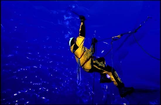 This is an extremely interesting glacier because most of its features are similar to those of the Perito Moreno. Satellite images do not show particular forms of surface drainage, which should be different compared to the Tyndall and the Grey. The glacier is not retreating significantly so we shouldn’t find a critical situation as in the Upsala. The glacier can be reached by sea thus the approach is not particularly difficult but it is rather slow.
Projects: the investigation is planned for January 2005.
Difficulties: unknown, however bad weather conditions due to the glacier’s exposure in the north and to the sea will be the most significant problem.
Final remarks
Expeditions performed so far have allowed us to delineate both the logistics and mysteries of glaciers coming down from the Hielo patagonico Sur. Results show that each glacier has its own special features due to various exposures, shape of the bedrock, rapid reaction to climate change, and relation between accumulation and ablation surfaces.
The general rule we can identify for these glaciers is that they are very small structures compared to the surface they drain and therefore they are glacial tongues that can reach extreme depths.
With the climate conditions of Patagonia a valley glacier could only exist over 1500 m asl whereas, with such temperatures, they can be found at lower altitudes, in climatic zones where it is unusual to find natural ice. This is the reason why glaciers such as the Grey or the Perito Moreno offer some extraordinary views, with immense rivers flowing down the woods. As a result, glacial karst topography in these zones is strongly linked to the intensity of ablation, which is considerable, making these places proper sanctuaries for this kind of research.
Moreover, their glacial front is submerged, allowing a risky but crucial investigation, namely the constant search for springs in frontal zones, an inch from the water surface. It is generally believed that water flow within glaciers is found on the contact surface between rock and ice, while our research shows the presence of prevalent runoffs at 100-150 m of depth, well inside the glacier. These runoffs end inevitably on the contact with the rock, in the final parts of glaciers with fronts on the land. The same is not true for glaciers with fronts in the water, where water carries on its flow at the level of the internal aquifer to finally plunge into the lake at shallow depth. Patagonian glaciers allow highlighting of this phenomenon, which so far has only been supposed. Melting processes in these glaciers are extremely intense and have a favourable geometry. However, in these final remarks we must absolutely mention the strong difference of forms and features of drainage networks among the glaciers we explored. We hadn’t predicted it at all; on the contrary, climate conditions seemed quite similar from one glacier to the other. Their enormous size seemed to protect them from variations due to the shape of the ice bed. Intake areas looked quite similar, so we expected the features of drainage networks and of caves to be the same. However this was not the case, each glacier is different, and the actual understanding of this point has been the most important result of explorations carried out so far. Reasons for this difference of behaviour can be diverse and we can only make hypotheses. First of all, one reason could be that the similar climate around the Hielo Continental is perhaps only apparent and due to the inadequacy of existing weather stations to evaluate its variation. Moreover these glaciers are very deep (well over 500 m), so side walls can influence creep strains and therefore rely on the shape of the valley, also on several kilometre wide areas. In addition, another reason could be that we started studying glaciers in the most unlucky period of the last millennium, when a planetary climate crisis is taking place, thus we are not studying them in their condition of stability but in crisis conditions, namely in a phase of transition. As a consequence there is a growing interest in research, but it is very difficult to interpret results because in such a phase marginal phenomena are normally magnified.
Besides, the uniformity of intake areas is just apparent, each glacial tongue drains AREALI SPECIFICI (specific habitats) of the Hielo Continental, which are actually very different from each other, both for the feeding and their flow downstream. After all these remarks we eventually realise that the age and the history of the ice forming each glacial tongue are both very big and very different from each other. As a result, glaciers have different physical qualities and mechanical behaviours: the most evident effect of the anomaly of Patagonian glaciers is their colour, but the most important one is probably their water permeability, which requires further detailed study.
However, all these aspects still need to be well understood, because so far we have only scratched the surface of a mystery. Through our project we want to make some step forward in understanding these glaciers, but most of all, we want to seize the opportunity offered by such explorations to raise awareness of the mystery and the absolute beauty of this part of our planet.
Mitre expedition 2005
Exploring caves in the extreme south of the Planet.
During this expedition some of the caves located in the most southern parts of the world were explored. The expedition was performed in close cooperation with the Centro Austral de Investigación Cientifica (CADIC) of Ushuaia and with the Sociedad Argentina de Espeleologia of Buenos Aires. The expedition lasted 15 days and was funded by the Società Speleologica Italiana, Club Alpino Italiano, Istituto Italiano di Speleologia dell'Università di Bologna, Museo del Fin del Mundo of Ushuaia, Provincia de la Tierra del Fuego.
 Members who took part in the expedition were Tullio Bernabei, Tono De Vivo, Giovanni Todini, Andrea Broglia (La Venta), Ernesto Piana (CADIC/La Venta) and Sergio Anselmino (Museo del Fin del Mundo).
In March 2004 Anselmino walked the whole peninsula on his own (650 km in 45 days), and noticed some cavities along the southern coast, near Bahia Aguirre.
As a consequence of his findings the La Venta group organised an expedition aimed at reaching and exploring these caves. Let us consider that the Peninsula Mitre does not present any traces of limestone, but is mainly formed by volcanic rocks (Lemaire formation), where until today the existence of FENOMENI IPOGEI (hypogea) wasn’t considered possible.
The main problem was that Bahia Aguirre is a rather isolated area; other difficulties were caused by the type of soil and climate. The area where research was carried out is located around 120 km from the last carriageway, therefore it was necessary to use a helicopter to reduce the time needed to approach the glacier.
The area is mainly formed by mountains, up to 1000 m high and surrounded by vast peat bogs and wetlands and by thick lenga woodland (southern beech): sometimes shrubs force to move on a sort of carpet hanging on rotting trunks’ deposits.
Climate is extremely variable in this area: even though we are in the Southern summer in a few hours we can shift from the sun to strong rainfall or snowfalls, with winds exceeding 150 km/h. Moreover, as we are talking about sea caves, both wave energy and often very strong and tides (up to 3 m) play a crucial role.
Using the helicopter allowed us to arrive at around 5km as the crow flies from the caves. We didn’t know the precise position but we just had some memories of Sergio Anselmino’s diary. Moving material required two days of transport on very difficult terrain but this allowed us to establish a base camp 210 m asl above the coastline, where we thought the caves might be located.
The coast, extremely rugged, is characterised in this area by high mountain walls interrupted by steep rocky channels that have been used as access routes to the sea. In order to move along the coast and in high water it was necessary to equip a cableway. After numerous days of research along a stretch of littoral zone, 2 km long, we detected, explored and mapped 14 caves for a total development of 467 m. If some caves had typical marine features and reduced length, others had tectonic features and are longer and more articulated. Amongst these caves there is the Cueva del Mitre, with a horizontal development of 160 m and formed by 3 entrances.
Despite the type of rock where the cavities open up, some of them include stalactite formations and mineralisation (all extremely interesting) that are currently being studied at the Istituto Italiano di Speleologia (Italian Institute of Speleology).
The presence of Ernesto Piana, archaeologist and anthropologist of the CADIC, allowed us to prove the absence of any human trace in the discovered cavities. On the other hand, in the surroundings, a new archaeological site was discovered. Remains of mussels, bones of guanaco and sea lion and traces of coal were found inside the cavity.
Caves explored so far in the extreme southern parts of the world seem to have been those in the province of Ultima Esperanza, in Chile, on the Pacific Ocean side. The new Mitre caves are located 500 km further south, just above 55° latitude. Beyond there is only the sea and the Antarctic continent, where in 2000 the La Venta group explored other caves, although in this case research was carried out within glaciers, not on rock formations.
Partner: Centro Austral de Investigación Cientifica, Provincia de la Tierra del Fuego, Società Speleologica Italiana, Istituto Italiano di Speleologia, Club Alpino Italiano
|
INSIGHTS: |